
Search Photos Record
Images
Metadata
Catalog Number/Object ID |
2014-033-00050 |
Object Name |
Map |
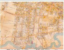
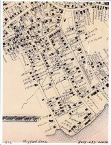
Title |
Marblehead Maps, 1872 & 1897 |
Caption of Imagae |
Colored maps of Shipyard to Downtown |
Description |
Two colored maps of Marblehead. One from the Shipyard Area in 1872 and the other is a map of Marblehead from Shipyard to Washington, School St. and Essex St. and Atlantic Avenue in 1897. |
Subjects |
Maps Marblehead History |
Year Range from |
1872 |
Year Range to |
1897 |
Catalog date |
2014-06-18 |
Print size |
8.5" X 11" |
Number of images |
2 |
Search Terms |
Map of Marblehead Walnut Street Gregory Street Cliff Street Nashua Street Allerton Place Commercial Street Chestnut Street Barnard Street Hawkes Street Lindsey Street Atlantic Avenue Prospect Street Cottage Street Geryy Street |
Lexicon category |
8: Communication Artifact |
Lexicon sub-category |
Documentary Artifact |
Collection |
Sullivan, Frederick |
Condition |
Excellent |